Royal Arch Loop
April 7-13, 2005
Thursday April 7, 2005
We had finally decided to tackle the Royal Arch Loop. I can say unapologetically that I have avoided this route for years because of the infamous "ledge". I don't like exposure, never have, never will, and I flat out refused to test my machismo or my mortality at this point in my life. However, for a while now, there has been talk on the various web forums devoted to diehard Grand Canyon hikers that there is an alternate route around the ledge. It seems it is no longer necessary to traverse this relatively short, but scary (to me at least) stretch of trail in order to enjoy this otherwise beautiful and remote area of the canyon. And so I agreed, envisioning a wide, flat thoroughfare on the opposite side of the ledge, wondering why people hadn't found this route long ago. The necessity of rappeling 20' down a cliff did not concern me. Although I've never actually rappeled in the real world, I have been to indoor climbing walls and dangled 30' above the floor and rappeled down. I was used to that. Also, recent reports said there were new ropes in place and so I was confident they were secured by experienced climbers, not us novices.
I picked up Shawn at his house at about 8am on Thursday the 7th. We were to meet Tom at his house and drive up in his Isuzu. We called Tom to see if he was ready and of course he was not, so Shawn and I stopped for breakfast. Shawn was a first time Grand Canyon hiker, though he had done Havasupai once, I believe. I noticed he was wearing sandals, which isn't unusual, but was surprised when he said he would be hiking in those. Not a good idea, I said, but he assured me he had done lots of hikes in the mountains surrounding Tucson (yes, there are mountains surrounding Tucson!) and it would be no problem. I didn't argue, figuring youth would trump everything else, and that Shawn, in his early 20's could outhike us old guys in his bare feet.
The trip north was uneventful and we had planned to rendezvous with Johnny and Gary at the general store in Tusayan. We eventually hooked up at about 4pm, did a little last minute shopping, and parked Johnny's car in the parking lot of that very large and very new hotel a bit south of the general store. We loaded everything onto Tom's 4 wheel drive Isuzu Trooper and headed out to the South Bass trailhead. Having done some research this time, and taking a map, we found the road out there with no problem, taking the Forest Service Road right there outside the park at the now closed Hopi Lodge. The road wasn't too bad. There had been considerable rain the week before but most of it had dried up and the dirt road, though rutted, was passable. When we passed into Havasupai land, we were stopped and paid the $25 to continue on.
Because of the remoteness of the trailhead, we had decided to spend the first night on the rim so we could get an early start in the morning. We arrived at the trailhead about 6pm or so, set up camp and relaxed, enjoying the sunset. Tom and I shared a tent, Gary had his own, Johnnie had a ground cloth and Shawn had a bivvy sack. We were expecting a relatively chilly night on the rim, but expected things to warm up considerably once we dropped into the canyon.
Friday April 8, 2005
At about 3am I woke up to pee and when I unzipped the tent to get out a clump of snow fell on my head! I was amazed to see that about 2 inches of snow had already fallen and that it was continuing to come down softly and quietly. Johnny had apparently noticed, since he had folded over his ground cloth and was under it. I called over to Shawn to see if he was OK. His Bivvy was completely covered in snow. He didn't answer. I figured he was either dead or sleeping soundly. Assuming the best, I left him alone. Not anticipating snow, since it was not in the forecast and because we went to sleep under a very starry sky, we had left most of our gear just laying around, not even bothering to cover things up. I guess camping 40' from the safety of a car makes people a bit careless. The problem now was that our gear, which we would need for the next 5 nights, was getting wet. I covered up as much as possible and went back in the tent. I figured we'd wait out the snow and begin the hike when it cleared a bit.
By 6am it was showing no signs of clearing. The snow continued to fall at a steady rate. By now everyone else was up and outside, talking about what to do. We would wait for the sun to come out, which it surely would, dry our stuff out, and start the hike. Hiking while it was snowing was not the issue. Having wet gear was. 10am and still snowing, noon, 2pm. By now we were in the Isuzu playing hearts and drinking scotch. It was still snowing. At about 5:30 we had to make a decision. Our gear was only getting wetter and at this point we were either going to have to pack up and head down the trail or spend another night on the rim. We had built enough time into this hike to start a day later. We debated for awhile and chose a third alternative. Head back to the village, get some hotel rooms, dry out all our gear, have a nice warm dinner and nice warm beds, and return to the trailhead bright and early the next morning to begin the hike.
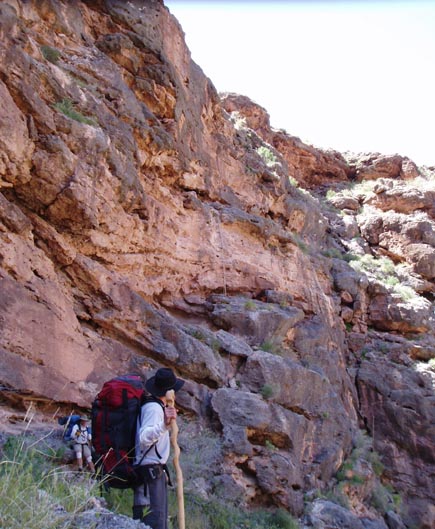
Images at the South Bass Trailhead |
 |
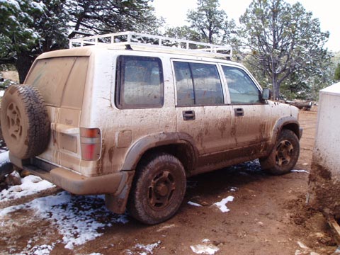
The trip back out to the village was about as rough and tense as any car ride I had ever taken. 30 miles of by now very wet and already rutted dirt road, never in good shape to begin with and now an absolute mess. One wrong maneuver and we would be stuck in a quagmire of mud and water. Been there, done that. It's no fun, and there was a real possibility we wouldn't be able to extricate ourselves. Tom's trooper has 4 wheel drive and a high clearance. We hung on for dear life, said very little and Tom somehow miraculously got us through this absolute mess. I was convinced that there was no way we would be able to return on this same road. I wrote off the trip mentally and began to think of alternatives so that the trip would not be a total loss. Meanwhile, Tom was talking about getting an early start the next morning while the water and road were frozen from the night before. I wasn't buying it, but said nothing.
We got the last two rooms on the rim, or so they told us, and hung everything out to dry. We set up the tents in the rooms, hung our sleeping bags from the fans, and draped every else over every hanger we could find. Then we went out to dinner.
The hotel room |
 |
Saturday April 9, 2005
We were up at dawn and repacking the car. I was skeptical but said nothing. It had stopped snowing sometime during the night and looked like it would be a beautiful day. We headed out and the road was about as bad as I had expected. We plowed forward, every puddle and rut being a potential trip breaker, and I'm not talking about small ruts here, as any of you who have ever taken this road can attest to. Just past the ranger station we met up with the Havasupai ranger who again collected $25 from us, despite our attempts to convince him that paying yesterday should have been sufficient. We asked how the road ahead was, since he was coming from that way, and he said it looked like someone had made it out the night before so it shouldn't be so bad. Since it was us that had made it out the night before, it did little to allay our fears.
Once again Tom pulled us through and got us to the trailhead. The car was practically unrecognizable with mud caked up to the roof. We got our gear ready, and finally headed down the trail, a day later than planned. At least we were on our way. The snow was gone within minutes, even before we got to the Coconino sandstone. Hiking was cool and pleasant, and the walk to the Esplanade and the junction to the Apache trail took about an hour. Tom brought along his new toy, a really nice GPS, but since it was so new he hadn't really learned how to use it to its fullest potential. We put in a few way points, found the junction of the Apache trail, and headed west. We stopped for lunch at about 1pm and continued on, eventually camping on the Esplanade below Montezuma Point, east of the dropoff into Royal Arch drainage.
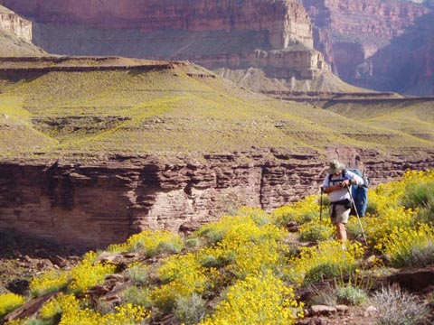
First hiking day and campsite |
 |
Sunday April 10, 2005
The next morning we took off and soon found a large cairn at the first drainage we came to. Accounts of which drainage to take are sketchy, and though we had planned to take the second drainage we came to, this cairn seemed so large that we decided to take it. It really didn't matter since it dropped a bit and then headed off to the west where it hooked up with the bigger drainage. Either one can be taken and you end up in the same spot within a short period of time. There was water at this point and we took a short breather. We were now in Royal Arch Creek proper and I knew that soon we would be coming to the "ledge". Eventually we came to a dropoff where cairns could be seen on either the left or right side of a spilloff. I was at the rear of the group and they took the left side. Thinking this was where we go right, I headed that way to reconoiter a bit. It soon became obvious I was on the non ledge path and I shouted across the canyon for the rest of the group to follow me. All did, except Tom, who wanted to get a closer look at the Ledge and possibly cross there. Within minutes I was high up on the right side and could watch Tom as he approached the ledge. From my vantage point maybe a hundred yards away, it looked like a shear cliff. I kept calling over to him to turn around and come our way. He insisted he could do the ledge and that from his vantage point it didn't look much better on our side. Distances are deceiving however. What he saw as a shear cliff on the right side was actually a maybe 4' wide path. Not exactly a thoroughfare but compared to what he was trying it was 5th Avenue. Once he stepped out onto the ledge I kept silent, not wanting to spook him but really hoping he would turn around. His internal frame pack is always overloaded and from my vantage point, it didn't look safe. He took the first step and paused for the longest time, maybe a minute or more. Then he stepped back and retraced his steps to join the rest of the group. The rest of us let out a sigh of relief.
My disclaimer here in the description of this area is this: First, I admittedly don't like exposure and am probably more sensitive to it than most. Second, I never really saw the ledge up close. From a distance it looked very imposing, but then again, from a distance, so did the side we eventually took. People have been doing the ledge for years, and I haven't heard of any accidents here. So be it. Take your choice.
That being said, the other side is no walk in the park either. (Well, technically it is, but we won't split hairs here.) The path climbs until it parallels a shear cliff and can't go any higher. At it's narrowest, it's maybe 4-5 feet, and at one point we had to take our packs off and crawl through a small opening to continue on our way. It was hard to see where this trail was leading! Eventually we started heading down but we knew there was a major cliff in the way. The trail took us seemingly to the edge where it went down through a crack, along a short shelf and continued down. We passed our packs through this crack, as it was too narrow to keep them on, and continued down. This was the last exposed section, and we were soon scrambling down the trail and into the drainage once again.
Royal Arch Canyon was slow going for us. There were some dropoffs and rock scrambles that took awhile to get past, made all the more difficult because we had decided not to bring any rope with us. It would have helped tremendously scrambling down these rocks and at least lowering our packs. There were pools at the bottoms of 2 of these scrambles and we got wet. Fortunately there weren't even waist high. The plan was to spend the night under Royal Arch but we came to a rather large dropoff at about 5pm or so. We had already passed the junction for the climb out the next day to we decided to camp right there in the dry creek bed, and day hike down to Royal Arch the next day. Although rain wasn't in the forecast, I'm always wary about camping in a creek bed, especially in a relatively narrow canyon. There was a quick escape route in case of rain, and so we settled here for the night.
Second day |
 |
Monday, April 11, 2005
We headed down to Royal Arch the next morning, all except Shawn, who was having a somewhat difficult time in the drainage with his sandals and wanted to rest up. After the quick scramble down the rocks we were in the drainage once again and continued down easily. There was no arch in site. Finally we came to a dropoff where Gary volunteered to scout out what was up ahead around the bend on the slot canyon. He scrambled down the rocks (the guy is a damn monkey!) and disappeared around the bend. He returned about 10 minutes later saying there was no arch ahead. We didn't know how much further it was, and given how slow we had travelled the day before, we decided to check it out from the vantage point of the plateau. We headed back to camp, packed up, backed tracked a bit to the junction out of the drainage heading east onto the plateau and towards the rappel.
Shawn did well on the plateau and was leading the group most of the way. Truthfully, we hardly spent any time looking for the Arch while we were on the plateau. Our thoughts were on the rappel up ahead. Eventually the trail started heading down gently through the plateau. It was obvious we were getting close. I was up ahead, and soon took off my pack to look around unencumbered. To say the least I was surprised at the steep scramble down to the area where the ropes were. I was expecting to be hiking along, find the ropes, rappel down and continue on our merry way. Yeah, right! The trail down to the ropes was slow going, and very careful going. We had to go one at a time, handing packs down and carefully climbing down a narrow area. Where we ended up was a shelf, about 30' long and maybe 5' wide, at the end of which were the ropes! We have no pictures of this area. We were too engrossed in other things!
Tom had actually led the way down this section, and so he was first along the edge, followed by Gary, Shawn, Johnny and I. We were to rappel in this order also because the shelf we were on was narrow and there wasn't much space to manuever between the people and the packs. Surprisingly, by the time I had gotten to the shelf, Gary was already gone! Explaining his decision later he said that he was sitting on the ledge, unable to see where the rappel ended, beginning to get very nervous. He decided if he didn't act quickly he was going to panic and so he blew past Tom, grabbed the knotted rope and went over the edge. Like I said before, Gary is like a monkey. I remembered back to our high school days when he would scramble up those damn ropes in gym class, all the way to the ceiling and back, while I'd be struggling to get up 10 feet! It was reassuring to know he was down at the next level and could guide us during our rappels.
Tom pulled the harness and necessary hardware from his pack. In addition to the knotted rope there were two straight ropes for the rappel. He handed Shawn the harness and Shawn began to untangle it, trying to figure out which side was in and which side was out. Tom had actually rappeled in the real world before. He pulled out the necessary clips and then he took out the instruction manual that came with the hardware and began reading!!! That was it! When I saw that, I was the one on the verge of panic. Tom had to read the damn manual to know how to do this?!? I said I'm going down like Gary did, inched past the rest of the group, grabbed onto the knotted rope and let myself over the edge. Once over the edge it is possible to see footholds and realize that the drop is not totally vertical. With Gary down below to guide me, I was down in seconds. Johnny, probably not feeling very comfortable about the whole thing either but never saying anything, followed me down. Tom began roping down the packs, and we handed the packs down through a second roped slotted area where there was room for all packs and people. Meanwhile, Shawn had the harness figured out, dropped over the edge and let himself down with no problem. When I asked him later if he had ever done that before he said no, but he had read a book on how to do it before leaving Tucson! Tom went down the knotted rope and we eventually continued on our way to the Colorado, about an hour away.
Shawn began to fall further behind on this stretch and we reached Toltec creek considerably before he did. We found some shade, ate lunch, and began pumping water. He showed up about 30 minutes later, very hot and very tired. He was having a rough time. The rest of us were experienced canyon hikers. We knew the value of shade when it was available, rest and water. We pumped and had Shawn drink lots of water and rest. We still had a long way to go today, given that we had lost an entire day of this trip to snow. We rested in the shade for about an hour and a half. We were hoping to make it at least to the Tonto Plateau above Garnet Canyon before camping.
The hike parallel to the river north of the Toltec drainage is slow going. Indistinct trail, boulder hopping and a lot of scrambling. The rocks are sharp and gloves would have helped a lot, but I think only two of us brought them. Shawn once again quickly fell behind. It was no surprise, given the rock scrambling and the damn sandals he had on. Within two hours he was so far behind that we began to get concerned. At this rate, we would not get out of the canyon on time. No big deal for Tom and I, but Gary had to catch a plane and Shawn had to get back to work. As the four old guys sat around discussing our problem, we decided on a plan. Shawn would hike in the middle. Two of us leading the hike and two following behind Shawn, prodding him if necessary to keep him going at a pace that would get us out of the canyon. He eventually showed up and we continued along. Shawn must have thought he was on a death march. That night we camped in Garnet Canyon. Water was flowing freely and we washed up and had a great meal. Shawn used the satellite phone to call his girlfriend and wish her a happy birthday and Gary called his wife alerting her to the possibility that we might be delayed a day. We also pumped water here, which would turn out to be a problem. The water was not good, and gave us all the runs. Fortunately, it didn't get any worse than that.
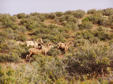
The plateau, the rappel and forward |
 |
Tuesday, April 12, 2005
The plan by now was clear. We made Shawn leave first, hurrying him out of camp an hour before the rest of us were ready to go. We knew the trail would be easy to follow. He had had no problem following the trail along the river the day before and it wasn't getting any worse than that. We would eventually catch up with him and prod him ever forward. At this point I'm guessing he must have been thinking what a mistake it was to go with these crazy guys. On our part, we were thinking either we get serious about motivating Shawn or we would be using the satellite phone he brought to call in a rescue party. Today was going to be a long day, maybe as far as 12 miles. If we were to get out in time, we would need to cross most of the plateau today.
We were able to make it all the way to Copper Canyon by about noon or so and holed up in shady nooks and crannies until about 3:30, when the sun was not so intense. We dumped what water we had left from Garnet and pumped more water here. It was a little better tasting than the other stuff that had given us the runs. Also, unless we wanted to head down to the river for water the next day, this was the last reliable water supply on the trip. The water in the drainage was not running. There were small pools which we pumped out of. Our original destination for the day was the junction of the South Bass trail and the Tonto. However, Tom was most interested in spending one last night on the plateau and we found a decent spot after the trail turned back south. We were about an hour from the South Bass/Tonto Junction.
Images on the Tonto |
 |
Wednesday, April 13, 2005
Again we made Shawn break camp and leave about an hour before the rest of us. The trail should be clearly marked we told him, and if in doubt, just go up. The distance we had to travel today was about 7 miles, but they were not easy miles. The trail climbs steadily on the east side of Bass Canyon after the junction of the Tonto, and later in the day it is sunny and hot, so we wanted to get an early start. Then it begins a steep path through the Red Wall until it levels out (relatively speaking) for a long traverse in the Supai formation. I was the last one out of the camp and didn't follow my own advice, briefly heading down the trail to the river. After maybe 5 minutes I knew I was going the wrong way, having been here at least three times before. I corrected myself and headed up. Just before the Redwall, I came upon the rest of the group. We lunched as soon as we hit the esplanade and then sent Shawn on ahead to tackle the last few miles of the trail. He was relaxing on top when we hit the trailhead of the South Bass. There was a group of men there who were getting set to hike down the South Bass the next day. They were having lunch on the rim and had a number of extra sub sandwiches they had purchased earlier in the day. They offered us the sandwiches and we gobbled them down with some cold beer we still had in the cooler in the car. Boy was that a delicious surprise. I don't think these guys realized just how good those sandwiches were to us after 5 days of dehydrated food.
Ascending the South Bass |
 |
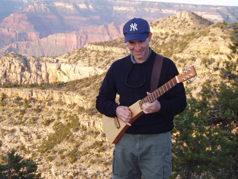
For the third time we headed down the road connecting the South Bass trailhead with the Park. We went back to where Johnny's car was and he, Gary and I headed off to Las Vegas while Tom and Shawn headed back to Tucson. Gary had brought along his "backpacking guitar" which he didn't take on the backpack itself because he was afraid of damaging it. But he serenaded us all the way back to Las Vegas with one request after the other, songs he probably hadn't played in almost 30 years. We stopped for a nice Mexican dinner in the historic section of Kingman (did you know they even had a historic district?) and then headed on into Las Vegas.