Thunder River, Grand Canyon Arizona
Oct. 10 - 13 1997
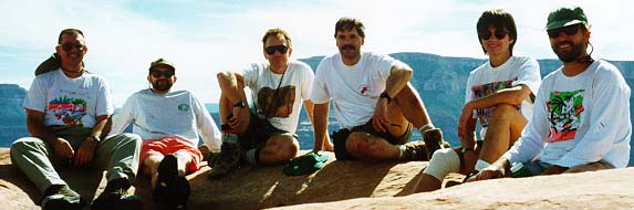
The hikers:[27k]. From left: Tom Ralston, Mike Brehm, Cheech Calenti, John Bernardo, Cheryl Underwood-Brehm, Jim Vanderslice. Missing are Frank Hays, Brian Hays, Rick Kroc.
Thursday October 09: This trip involved quite a bit of coordination, since we had people coming in from all parts of the west. Tom, John, Rick and I were coming from Tucson, Mike and Cheryl fom Salt Lake City, Jim from El Paso, and Frank and Brian from Grand Canyon Village. The Tucson contingent (minus Rick) left Tucson at 9am for the trip to Jacob Lake lodge, where we were to rendezvous with the rest of the group. By 10pm we were in our cabins, discussing who would be carrying what, and debating which of the trails we would be taking down to the esplanade. All reports we had read said the Thunder River trail was 5 miles longer to the junction of the Bill Hall trail. However, the Bill Hall was much steeper. The three members of the group who had not arrived were Frank, his wife, and 15 year old son Brian. We knew that Frank, an employee of the Park Service at the Canyon, wanted to go down the Thunder River Trail. However, after much debate and orange vodka, the rest of us decided that we'd try the Bill Hall. We didn't want to hike 5 extra miles the first day. Frank and his family had not arrived yet so we weren't clear on their reasons. The rest of us however, had made up our minds. Our plan was to leave the lodge at 7am and be on the trailhead by 9am. None of the group had ever been to either trailhead and they were both about 35-40 miles in on unpaved forest service roads.
Friday, October 10: Frank et.al. showed up the following morning.
His wife had decided not to join us. Frank informed us that while
he had never taken either trail, many of his co-workers had and they said
the Bill Hall was very steep. He also thought that the Thunder
River trail was only three miles longer so he and his son decided they
were sticking to their plan. Rick, who was concerned about his knees,
decided to do the Thunder River with Frank and Brian. We jumped in
two cars and took off for the trailhead, picking up the forest service
road a mile or so past the Kaibab Lodge. We followed the directions
outlined in John Annerino's guide to the canyon and got there with no problem.
However, do watch the roads carefully, and watch the odometer. We
made a quick stop at the Kaibab Lodge general store because
Tom's shoes, [38k]
were falling apart. After picking up Shoe glue and duct tape, we were off.
We followed Frank, Brian and Rick until they turned right to
go to the Thunder River Trailhead. We continued straight and then
off to the west until we reached the parking lot of the Bill Hall Trail.
We were very surprised at the number of cars in the parking lot.
It was a beautiful, clear day, but the forecast was for rain both Saturday
and Sunday.
Our first problem was deciding where the trailhead actually started. Just beyond the far end of the parking lot the road continues although it's marked for pedestrians only. Some of the group thought we should continue along the road while others said we should take the trail which drops down to the left of the road immediately past the fence. This trail is the correct way to go, do not go down the road! Fortunately, we chose the correct direction from the start. The first surprise was how long we actually followed the trail along the rim and through a burnt out knoll area before reaching the drop off the rim. I'd estimate it's about 20 minutes to a half hour before the drop off actually starts.
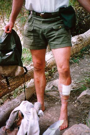
Once it does start, it drops quickly but not very precipitously through the Kaibab and the Toroweap and then swings way to the west before dropping steeply once more. On this relatively flat area before the second drop are some of the most incredible vistas I've ever seen in the canyon. From here you can see the river heading west and south. The canyon just stretched out in front of us[35k] for as far as we could see.John Bernardo was leading us down the second steep drop and was about 5 minutes ahead of us, out of sight. I had been told by some hikers I met at the Jacon Lake lodge that there was one area where it might be prudent to take off the packs and lower them down. Unfortunately I didn't mention it to John and he came upon the drop, tried to do it with his pack on, and took a tumble, head over heels about 15 feet down. When the rest of the group got there John was up lookng for his glasses, very scratched up but with no serious injuries as far as we could tell. Here are what John's legs [36k] looked like two days later. When John returned to Tucson and saw his Dr., he was told he had indeed cracked some ribs. He must have been in pain the entire time but never complained to any of us. What resolve and determination. (probably the scotch helped too!)
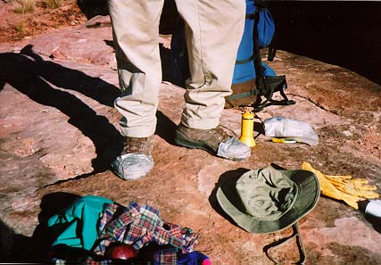
After making sure John was OK, we continued down the trail. It becomes a series of short steep switchbacks before it reaches the Esplanade and the Junction with the Thunder River Trail. These switch backs are not dangerous, just tough on the legs. We arrived at the junction at about 12:15, cached some water, had lunch and continued on. The Esplanade itself is easy hiking but care should be taken to not lose the trail, since the ecosystem is fragile and going off trail can damage it. Also, there are long stretches of just rock, so following cairns is necessary. We walked for about an hour on the esplanade before resting at a nice shady overhang which it was easy to see had been used as a campsite. The overhang provided protection from rain and there was a nice natural rock table right next to it. Tom climbed the rock under which we were resting and found two large water holes. We brought up our water filters and filled up.
Here are some images of the esplanade
A few minutes after this spot the trail starts descending through the Kaibab formation and then begins it's descent of the Redwall. It's a short but steep grunt through this area and the trail is well maintained. Even after getting through the Redwall there is a long walk out into Surprise Valley. John, Jim and I got to the fork of the Thunder River and Deer Creek trails a little after three. Mike and Cheryl took an hour break on the Redwall and Tom hung out there for about a half hour also. While we were coming down the Redwall we met a hiker coming up and inquired about camping spots in the valley. He suggested we head east at the junction and follow it until just before it drops down to Thunder River. Jim and I headed in that direction while John waited for the rest of the group. About a half hour after leaving the junction we found what looked like a good area. I scouted it out while Jim went back to see if Mike and Cheryl needed assistance. It turned out they didn't and came into camp about 5pm. A half hour after that, Frank, Brian and Rick walked in. Although we hadn't really discussed where in Surprise Valley we'd meet, Frank had been to this spot before (by walking up from the river) and assumed we'd be camping there.
Here are some images of the Surprise Valley campsite.
We were absolutely beat that evening but feasted on a wonderful Spaghetti dinner, complete with fresh pasta and italian sausage, grated parmigiana cheese, fresh italian bread, fresh garden salad with according to Rick our choice of 6 salad dressings ( italian, italian,italian.....) and a nice merlot. It was fantastic and we all slept wonderfully that evening.Saturday Oct 11: Frank and Brian took off the next morning to spend the day at Deer Creek and then the night on top of the Redwall. They had to be out of the canyon on Sunday. The rest of us headed down to Thunder River and Tapeats Creek. It's very difficult to describe Thunder River because the river itself defies logic and everything one would expect to see. It literally pours out of the side of a 500 foot limestone wall. It's absolutely breathtaking and nourishes a lush, misty, fern covered riparian area that is heaven within the walls of the normally dry canyon.
Here are some images of Thunder River.
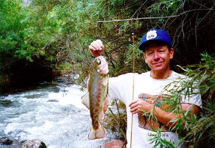
At this point we split into groups, with Mike and Jim heading to upper Tapeats, John, Cindy and Rick staying near Thunder River, and Tom and I heading down lower Tapeats to explore. Having been told it was good fishing in Tapeats, I had a brought along a fishing pole (the telescoping kind). While mother nature called Tom I set the rod and reel up with a little spinner and cast in. I pulled in a trout on the first cast! All told I fished for about an hour. I caught 5 trout and kept four for dinner. Here is an actual unretouched photo* of one of the trout I pulled out of Tapeats Creek.
It started raining on the way back to our campsites from Tapeats. Steady but not too hard, and everyone headed to their tents when we hit the plateau. Every sensible person that is. Tom and I made hot chocolate and headed up to explore an overhang I had noticed the day before which I thought might be nice in the event of inclement weather. It turned out the overhang was big enough for our tent and a lot of people so Tom and I relocated by unpegging our tent and carrying it fully assembled about a quarter of a mile to it's new location. It was during this move that the wind decided to pick up and the rain came down harder. None the less, we had made a good choice and the entire group came up to the overhang for a dry place to stretch out, have dinner, drink most of our "hooch" and tell a great many jokes. We had a great time. It was at this time that we decided to break up the return hike by leaving this spot the next day and heading up the Redwall to camp at the water source we discovered on Friday. We would take our packs to the junction of the Deer Creek trail, day hike to Deer Creek and then head up the Redwall in the afternoon. Everyone agreed with this idea because the thought of tackling both the Redwall and the climb to the rim in one day was overwhelming.
Sunday Oct 12: We packed up and were out of camp by 9:20. We arrived at the junction to the Deer Creek trail in about an hour, cached our packs and continued to head west along the Deer Creek trail. Cheryl and Rick decided to forego Deer Creek and tackle the Redwall. It's about two miles and relatively flat to where the trail drops into the drainage of Deer creek. The trail crosses a significant rock slide, skirts around an overlook for the upper Deer Creek Falls, and then descends. Don't bother trying to see the falls from this point, it's impossible. The trail drops quickly and the upper falls comes into view. It is quite beautiful. A side trail leads to it's base. The trail continues down and crosses the creek, then heads due south to the slot canyon. It's very lush in this area, and evidence of a recent fire is everywhere. However, we didn't see any deer. The trail eventually hits the beginning of the slot canyon and stays above the slot and off to it's west side the entire time. Within a short distance the water is hundreds of feet below the trail and the trail gets precariously narrow. This section spooked me and that was just with a day pack. With a backpack I don't think I would have had the nerve to continue. However, this canyon is breathtakingly beautiful and should be explored, albeit carefully. Once past the slot canyon, the trail opens up to a scenic overlook of the inner gorge and the Colorado River. It is a short jaunt down to the river and to the mouth of Deer Creek, with a majestic water fall emptying into the Colorado. Tom and Jim went all the way down and took pictures. The rest of us headed back to the head of the slot and bathed and had lunch.
Here are some images of Deer Creek.
We then backtracked to the trail junction, got our packs and headed up the Redwall, which took less than an hour. Cheryl and Rick had scouted the area on the esplanade where two days prior we had gotten our water. There were some nice camp sites behind the big rocks facing south west. We watched the sunset, took some pictures, had a nice meal, drank the rest of our "hooch", and played a word game introduced by Mike. All I can say about it is "Hooch is, but liquor isn't." It was cooler above the Redwall but still comfortable.
Monday Oct 13: We broke camp and headed back across the Esplanade to the junction of the Bill Hall and the Thunder River trails. We reached the junction, approx. 2 miles, in an hour, took a break and tried to give as much of our remaining food away as we could. We retrieved our cached water and headed up the hill to the first series of short, steep switchbacks. Frank had said there were 49, but none of us could keep track. We conquered the switchbacks, climbed the rock where John took his spill and then headed east around Bridgers Knoll. We stopped at a wonderful overlook about 1/2 hour from the top to have lunch and enjoy our last moments in the canyon. We climbed out at 1:10pm, 2.5 hours after leaving the junction at the Esplanade. From there of course it's another 15-20 minutes back to the parking lot. We began and ended this fine trip with some wonderful mambo music, and celebrated our return with dancing and a few nice cold beers at the car. Wonderful trip.
* OK, I lied. I touched it up a bit. All right already, quite a bit!Well, I asked for contributions to this page and so I got what I deserved. Here are
Cheryl and Mike's Top 12 Clues You've Been Suckered Into an All Expense Unpaid Grand Canyon Adventure With Cheech, Tom, and John.