Monument Point to Deer Creek/Kanab Creek and out Kwagunt Hollow
April 3-8, 2007
Dave's Account
Tuesday, April 3
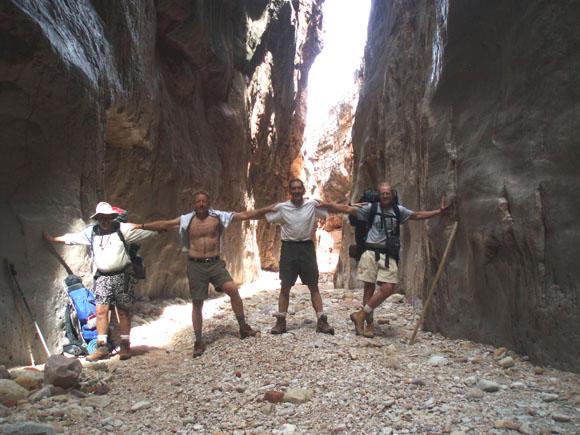
We descended into the canyon from the north rim at Monument Point on the Bill Hall trail at approximately 2 pm. We had dropped off a car at our exit point, Sowats Point, maybe 10 miles away as the crow flies, but many more miles of Park Service dirt roads away, by car, and 6 days away by foot when a detour to the Colorado River is included. That was the plan.The path down to the Esplanade was steep and quite rocky in spots, nothing at all like the south rim Kaibab trail (the Interstate of Grand Canyon trails). A time or two it was expedient to doff packs and hand them down over particularly difficult points.
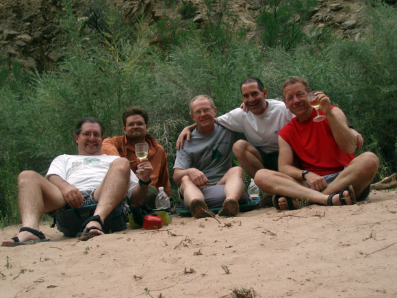
As is our custom, we spread out, each hiker striding or moseying along individually or in pairs. It took about 2 hours to get to near the end of the Esplanade, before dropping down the Redwall. Tom suggested stopping for the day but we decided to continue. It took maybe one to one and a half hours to get to Surprise Valley from the Esplanade. So it came to pass that, after dealing with a backpack equipment problem, Tom, Dave and Gary, as dusk was upon us, found Cheech and Shawn in repose at our first camp site, a quiet, level spot in Surprise Valley. A warm meal from a 4 oz. bag of freeze dried food, a sip or two from a shared bottle of spirits, a glorious view of the stars and the eventual nearly-full moonrise highlighted our first night in the canyon. Because the extended forecast called for clear skies and warm weather, no one brought tents. Did I mention quiet?
Images of the Esplanade |
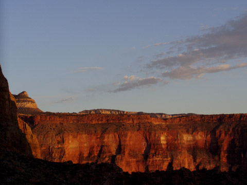 |
Wednesday, April 4
The next morning we headed west and descended further towards Deer Creek. It was about 2 hours of hiking. We stopped for a lunch break at "The Patio", a beautiful, open area of rock just before Deer Creek enters the narrows. It was cool and invigorating enough to encourage a quick rinse off. Here we were soon to encounter nearly a dozen up-from-the-river raft trippers taking a mid-day hike. Some were there to imbibe and, "like commune with nature, man", while others blew on by with serious rappelling gear, their plans for the day obviously a little less sedate. After lunch we continued through the narrows and within 10-15 minutes were heading down the escarpment to the river. There is an area in this slot which requires paying attention. It is narrow but there are good upper and lower hand holds. It takes maybe 30 seconds to cross. Soon we were down at the Colorado where the rafters were tethered. This stretch of sand was barely 100 yards from where Deer Creek bursts out of the escarpment and plunges maybe 100' to an aquamarine pool, before spilling into the Colorado. Tom was the first to notice that the rappellers had somehow negotiated the ~200' of above-the-falls escarpment and were now, obviously, trying to figure how to get the rest of the way down, the only possible way being either in or right next to the rushing water of the falls. There was no going back up and out for these folks.
At this point on our second day Shawn was feeling less vigorous and had found a shady spot to nap in an attempt to rest up and to avoid the heat of this lower elevation. Since we were interested in seeing the rappelers make their way down the sheer, wet rock face, we did not continue on towards our next campsite until 3 p.m. This was to be Fishtail Creek, nearly 3 miles away along the Colorado. There was no trail for much of this distance and where there was, it was very difficult to find and/or difficult to travel. We were fortunate to have the rafters agree to ferry our packs down to Fishtail, so we had minmimal encumbrances as we scrambled along the loose rock-slide surface of much of the river's edge. I would guess the surface was ~20 degrees from the horizontal, but when the loose sandstone and/or shale was slipping and sliding beneath our feet, it felt much steeper.
Read Steck's account before hiking this section. We didn't and it would have saved us a bunch of scrambling on loose talus and steep slopes. We followed low along the river until we saw a large outcrop in the distance. Not knowing whether we could get around it at river level, Gary and Cheech took the "high road" while Tom, Shawn and Dave went forward on the "low road". Had we read Steck's account, we would have known that there was a low way around the outcrop. As it was, Tom, Shawn and Dave headed up before discovering it and wound up doing much more sliding and scrambling than was comfortable. Cheech and Gary found the high trail and yelled for the rest of the group to follow. Then they headed towards Fishtail, sensing there might be problems with Shawn and knowing they had to get to the backpacks and the flashlights. Tom, Shawn and Dave continued along slowly. Hands were scraped, trousers torn and spirits dipped. Shawn was having the most difficulty, physically, still not feeling as vigorous as would be preferable for this trek. Beyond the most severe loose rock slopes, but with still some difficult trail yet to pass, dusk was approaching and Shawn hit bottom. Fortunately we were off the high trail and had made it to the river, but were still about 1/2 mile from the campsite. It was decided that Tom would go on ahead to find the campsite and, we certainly hoped, Cheech, Gary and our packs with our flashlights. Dave would, in the meantime, scoot a short distance ahead (100 yards?) to a bit of sandy shore, pump water and return to re-hydrate Shawn. As it turned out Shawn's condition was much more severe than we'd realized and before Dave returned with a bottle, Shawn had collapsed on the sand, incoherent, very confused and delirious. Dave encouraged him to drink, left him some water and returned to the pump/filter and the rest of his gear on the sand and settled in for the night. About 45 minutes later Cheech arrived with a light. The sun had set and there would be no moon in the canyon for many hours yet, so it was quite dark, but with the light Dave and Cheech found Shawn who had recovered some after drinking some water. He was coherent and after sitting up and drinking and nibbling some more while Cheech was recovering all the discarded gear except Shawn's hat and bottle, we laboriously made our way via head lamp the ~1/4 mile to the campsite. Tom met us part way, but Gary wasn't feeling well and stayed at the campsite. A sandy campsite was most welcome and, except for some toads hopping on Dave's head in the middle of the night, we all slept soundly.
Thursday, April 5
The next morning we headed out as early as possible with the daunting prospect of having to negotiate 4.5 more miles of rocky shoreline, this time with our full packs, but with a full day to do it. Shawn was improved but still not feeling as well as he would like. About 2 hours, and, maybe, 1 1/2 miles later, we were near the river when we heard what could have been angels from above, but was, in fact, a large group of river rafters who called out, "Want a lift?" It took us, oh, .2 nanoseconds to respond, "Yes!". 'twas the Miracle of the River. A group of ~12 professional river guides who had waited TWELVE YEARS for a private permit, were on a busman's holiday, just transporting themselves down the Colorado, no passengers. One has to assume that they were all "type A" professionals because none of them was, apparently, willing to be a passenger, so there was a vessel for everyone of them. Kayaks and larger rafts. We 5 split among 3 rafts and I doubt if any of us has experienced anything quite as nice as floating down that river as we watched the rocky shoreline go by.Fishtail Canyon to the mouth of Kanab Creek |
 |
 |
Friday, April 6
Friday morning was the start of the "boots wet" phase of the trip as we'd be crossing the ankle to thigh deep Kanab ~100 times, crisscrossing back and forth, as we made our way upstream. Unfortunately, within about 1/2 hour, Shawn realized that he just wouldn't be able to continue for three more days. Tom and Cheech returned to the river with Shawn while Dave and Gary continued upstream. We had a satellite phone with us and Cheech got a hold of the park service. We did this only as a last resort after seriously weighing all of our options. Given the slow speed at which Shawn was moving, his unsteadyness on his feet, and the fact that we had 25 rough miles ahead of us over three days led us to believe we would not be able to negotiate the sometimes rough terrain of chockstones, scrambles and creek crossings that lay ahead with a person who was basically incapacitated. It would have put Shawn in jeopardy and the rest of us also. We also knew a rescue from within Kanab Creek would be considerably more difficult than a rescue from the wide open confluence of Kanab and the Colorado. At first the NPS was very reluctant to send a helicopter for Shawn, suggesting that they would extend our backcountry permit and that we should nurse Shawn back to health and hike him out, but when the symptoms of Shawn's Wednesday night were described, along with the fact that he was not keeping down food or water, they decided to fly him out. EMT personnel did some tests on Shawn upon their arrival and the readings were not even close to normal range. Dehydration? Hyponatremia?
Dave and Gary, in the meantime, scrambled over the many boulders and splashed through the Kanab until mid-afternoon when we reached what we thought was Scotty's Castle, our next campsite. We had no water filter/pump, but Gary had iodine tablets and Dave had a pot and matches, so we were good to go. A few hours later, and after some extra back-to-the-river distance, Tom and Cheech arrived only to announce that, due to our not having a complete map, we had settled in at the faux Scotty's Castle. Hike times were about 3 hours to the junction for the Slide of Sussurus and another two or so to the false Scotty's. An hour or so further upstream was the real thing and a very nice, grass covered spot it was. N.B. You better have a topo and compass for this hike and you better know how to use them. GPS' are worthless in steep canyons.
 |
Saturday, April 7
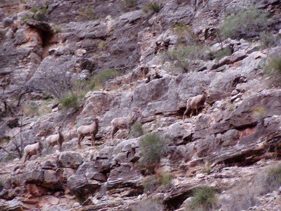
Saturday we continued up the Kanab. A few times we had to remove our packs, scramble up and over some house-sized boulders, and pass packs one to another, but nothing too treacherous. Showerbath Springs, with it's veil of emerald ferns and dripping water was beautiful. A cougar track larger than my hand was, um, interesting. Herds of Bighorn that edged along what appeared to be vertical rock faces were great to observe. We passed the point where the Kanab trickled to a stop (or a start, I guess would be more precise) without comment and around noon, after a lunch break we turned into Jumpup Canyon. It should go without saying that there are no road signs and there was frequently a small degree of concern that this turn or that was, in fact, following the prescribed route, but we always seemed to figure it out correctly. There is a fine campsite at the junction of Kanab Creek and Jumpup. On the left and up the short path to the bluff. However, there is no water here. Approx. time to the junction was maybe 6 hours.
 |
Jumpup Canyon was a prototypical slot canyon. If you wanted to film a 1940's "B" western movie with an ambush in a slot canyon, here it was. Sheer walls, maybe 200' high, with the width getting down to as little as ~15'. Neat. Easy to walk gravel, for the most part, but no place you would want to be during a flash flood. A few miles in, and 6 miles from where the Kanab last flowed, we took a 1/2 mile detour into Indian Springs to re-fill our bottles in Obstacle Pool. This supposedly perennial water source was dry. Doh! Decision time. Go back the 6 miles and refill and lose a day, or proceed with 3 liters between four guys. At worst there would be no water until we ascended the canyon, and that would be an uncomfortable time of it, but we were confident/foolish enough to press on and were rewarded with our second miracle when we found a 4' diameter, 4" deep pool near the entrance to Kwagunt Canyon, our exit route. We were happy campers.
 |
The easy hiking of Jumpup was replaced with some serious boulder hopping as we made our way to our next, and last, campsite. As we gained elevation we encountered a pair of nestled "C" shaped grottos, with dripping waterfalls, one flowing into the next. This seems to be the only viable campsite in Kwagunt. In looking for a way up the canyon, the bypasses are mostly on the right. The bypasses can get steep, but there is no exposure except for a short once leaving the campsite. We camped between the two waterfalls and after a particularly hearty dinner, as we split some food that we had gotten from Shawn, we settled in to the sounds of serenading frogs. No sooner had we retired when a sand storm hit us for maybe an hour. If we hadn't already been in our sleeping bags we would have had to chase them down as the winds was fairly wicked for a while. At this point of the trip a little sand in our hair and clothes was of no concern. Later that night Gary and Dave awoke to the sound of a rustling animal that was digging up some food we'd spilled the night before and had not buried deeply enough. Never did ID the critter. Skunk? Dunno.
Sunday, April 8
Sunday and some more serious boulder hopping for an hour or two until we, again, had to study the map and decide which was the best way to get to a pack trail that would eventually get us up to the north rim. At the only serious junction decision, we decided to go to the right, which according to Dave's math was slightly longer but not as steep. By 9 or 10 a.m. we had found the pack trail and now it was just a case of some serious elevation gain, one foot ahead of the other, for a few miles. Around noon we reached the car we'd left at our arrival point. Piece of cake. Even though the ice in the cooler we had left behind had melted, the beer and bottled water were mighty fine. How could they not be, at this point?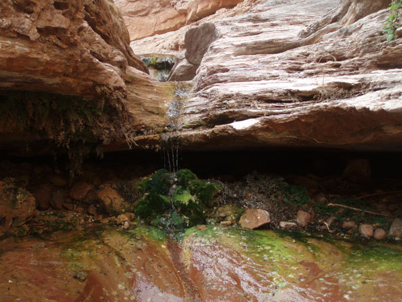 |