October 1994
New Hance west to Grandview.
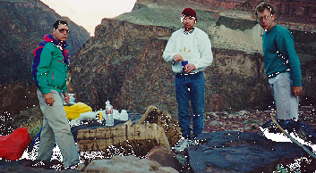
The hikers, left to right. Tom Ralston,
Cary Sadowski, Cheech Calenti
(I'm still looking for a photo which includes our 4th person, the honorable
Eugene Sweeney.)
Oct 20 - 24, 1994. This trip took us down the New Hance Trail to the river, west along the Tonto Plateau, up the east side of Horseshoe Mesa and up the Grandview Trail to the top.
We reserved a room at the Bright Angel Lodge for the evening before,
but when we finally arrived there (at 12:30am the morning of the hike),
the night desk person couldn't find our reservations. We had in our possession
a copy of the confirmation but she insisted there were no rooms left and
called around to find us a room, finally locating one in Tusayan. So we
headed back and bedded down there.
The next morning we headed out to find the trailhead, which is one of the
more difficult to find. There are no markers from the road, and without
the very exact map and directions given to us by perennial Grand Canyon
hiker Yar Petrsyn we never would have found the trailhead. It is 3.8 miles
east of the Grandview turnoff and 1.1 miles west of Moran Point. There
are some "no parking" signs on the north side of the road, and
the nearest place to keep a car overnight is at Moran Point.
Four days before, a storm had dumped 7 inches of snow on the South Rim,
but all that remained were a few patches in shady areas. The temperature
when we started down at 11:45 am. was a pleasant 60 degrees F.
The New Hance is not a maintained trail. The two friends we took on this
trip were novice hikers, and first time Grand Canyon trekkers. Not having
anything to compare it to, and never having been down the Bright Angel,
or what we affectionately call the gateway to the "Grand Central Canyon"
because of it's constant traffic, they didn't think it was such a difficult
trail. Tom and I thought it was tougher than most, and it was slow going
because of snow and wet trails until we got through the Coconino.
It took us 5 hours to reach our campsite. This rate of 1 mph was about
the same as our descent down the South Bass.
The remoteness of the trail is what made it nice and until the second day at the river, we didn't see another person. We set up camp about 1.5 miles from the Colorado below the Tonto in the old rocks. The stream which originates in Red Canyon (the canyon the New Hance follows) comes to the surface at this point and the site had more than enough sandy area for tents, and smooth rocks for relaxing.
We packed up camp the next morning and headed down to the river. Our plan was to spend most of the day at New Hance Rapids watching the river runners and then head west along the Tonto and spend the night at Mineral Canyon. Hance rapids are among the most "technical" in the inner gorge, from what river runners tell us. A group consisting of a couple of big inflatables and then some kayaks came by within the hour. The inflatables went right on through, but the kayakers beached their boats and spent at least an hour going up and down both sides of the river studying it carefully. Then they got together to compare notes upstream where they were away from the currents. To complicate their trip through the rapids, the water level was considerably lower than normal, which exposed some huge rocks all throught he rapids, while seeming not to diminish the turbulance of the water a single bit.
After spending a lovely day at the river we decided to head west but our plans of getting water from the creek as it flowed into the river didn't pan out because the creek went underground about .5 miles from the Colorado. Rather than pumping Colorado river water, which significantly shortens the life of water filters with it's heavy concentration of silt, we headed back up the New Hance to where fresh, clear water was bubbling from the ground. We filtered it anyway of course, and then were on our way. During our stop at the river, in addition to talking to the kayakers, we also met a group of 5 which had come down the Tanner and started heading west to the New Hance when they encountered a rock slide. They said they had headed back to the Tanner and hitched a ride with a river running group down to the New Hance and were now heading up. They had a young girl with them, probably no more than 13 or 14 years old. This may have had something to do with their not wanting to try to traverse any rocky areas.
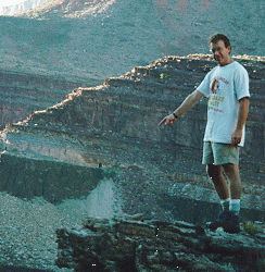
The trail heads west through the sand dunes and climbs slowly through the Hakatai shale, affording spectacular views of the river as the trail parallels it close to the edge. Finally it climbs up into a wonderful area of huge boulders, sandy ground and some grotesquely shaped limestone formations. Our immediate thought was to camp thee, but we realized we hadn't really hiked very far and need to get further along towards mineral canyon. At the mouth of Mineral on the east side of the Tonto we headed off the main trail and found a lovely wide open area on the plateau, with views in all directions, just perfect to watch the full moon rise as the sun was setting. This was our campsite the second night.Also from here there is a great view of the Hance Asbestos mine on the north side of the river.
The next morning we broke camp at 9:15, crossed Mineral Canyon and headed
to Hance creek, where we stopped for lunch at 12:45. The view into Hance
Creek from the plateau is spectacular, and there are many scenic overlooks
into the drainage, where the cottonwoods were just turning their autumn
colors. We lunched on the west side of Hance creek under and overhang,
and after refilling our water containers in the creek, headed out to conquer
the redwall. The trail crosses a saddle on the west side of Hance Creek
and immediately begins a steep ascent. Looking into the distance, it's
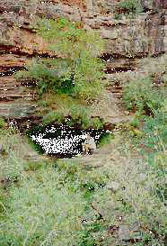
impossible to see where the trail breeches the Redwall. At the base of
the Redwall is Miners spring , where we
filled out water containers. There is no water on Horseshoe Mesa. The ascent
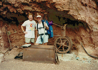
of the redwall at this point is steep, but towards the top we were rewarded
with an abandoned mine site , and related
paraphenalia. We explored the main shaft to the end, about 300 yards. There
is a side spur which bracnhes off to the left at about 200 yards in. It
peters out more quickly and isn't as wide or high as the main shaft. There
were lots of venting pipes in both shafts, and it was in the second that
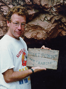
I found remnants of a Dynamite box ,
probably from the turn of the century. Warning, If you handle
any of the artifacts in the area, please carefully return them to their
exact position!
The ascent from the mine to the Mesa is particularly steep and narrow,
and I considered it the most harrowing part of the trip. At times it was
necessary to scramble on all fours, but eventually we got to the mesa,
which was strewn with a lot more evidence of Peter Berry's mining operation.
There is an outhouse on the Mesa, as well as some stone ruins.
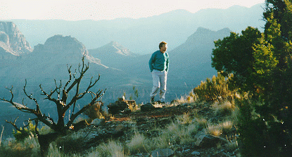
We headed out the west side of the Horseshoe and found a nice campspot which afforded panoramic views of the canyon. Sunrise on Horsehoe Mesa was spectacular. It was a chilly morning but once we started up the Grandview, we warmed quickly. It's about a 2.5 hour hike from the ruins on the Mesa to the Grandview Parking area.